Victoria - July 2009

Early one morning, we hopped in the car and headed towards Geelong (on Western Port Bay) with the intention of driving as far as we could along the Great Ocean Road, leaving time for a same day return.

First, we stopped at Queenscliff a beautiful seaside area where the car ferry arrives from Portsea (on the other peninsula in Port Phillip Bay). Queenscliff has many historic buildings and from the train station you can take a 'tourist' run around the Bellarine Peninsula on one of the older style trains.


We had a look at the Queenscliff marina. There were heaps of pleasure boats and lots of fishing trawlers were moored here also.
The Port Phillip Sea Pilots alarm bell in the park at Queenscliff is for marine emergencies only with heavy fines for any silly 'bell ringers'. Once out of the Bay and into Bass Strait the seas can be very unpredictable with big waves, so the sea pilots take this sort of thing very seriously!

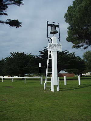
Some of the beautiful old homes, hotels and buildings in Queenscliff are being very well restored.

The water is beautiful, crystal clear and clean. From the jetty the water looks shallow but it is quite deep, just so clear.


In summertime, Queenscliff gets very busy when a lot of Melbournites come for holidays to the warm sunny beaches and beautiful scenery.
Marine traffic comes through these narrow heads, in the channel between the two bay peninsulas, Point Nepean and Point Lonsdale. Apparently something like 8,000 marine vessels pass through each year.
Point Lonsdale Lighthouse
Fort Queenscliff was set up to protect this part of Australia's huge coastline.

Attention!!! Eyes Right!! Obviously someone is standing there with a chip.

The Point Lonsdale Lighthouse

The sign says it all - Bass Strait - straight ahead - all ocean until you reach Tasmania!

Port Phillip Heads Marine National Park

There are some gorgeous rock forms and windblown landscapes here at the Point.

The waves appear to be a grid, due to the direction of the wind, waves and the tides.

Naturally, sealife and birdlife are quite at home here in the dunes and protected areas, but even so, the dire situation the Hooded Plover's are in must be averted ...

These old bunkers scattered along the beach at Point Lonsdale are part of history in the area, showing that it was important to protect the coastline during the war years. The scope of the view is very wide along the bay, the heads and out to sea.


Queenscliff is really a good area to begin your journey up the Great Ocean Road, one of Australia's most famous for it's scenery of spectacular cliffs and beaches. In many parts, the road is right next to the water and you can get some magnificent views from the higher sections of the road.


One of Victoria's world famous surfing beaches is Bells Beach. When the weather is right, this area pumps with huge waves, ideal for international pro-surfing championships. There is quite a big slope down to the water. We visited in winter, so there weren't a lot of people around. Summertime would be quite different and to swim here would require that you be pretty confident and competent in the water and surf.


Many of the houses are built to take in the commanding views around them. Some pretty amazing architecture ideas have been invented!


We spent 6 hours driving up and back with stops along the way at seaside towns such as Anglesea and Lorne, where we had fish and chips. There is still a lot more road to go. Next time, it will have to be for more than just the day!

Macleay Island - Queensland 2007

Moreton Bay is a vast Marine Park with some 365 islands dotted throughout. The principal residential islands in southern Moreton Bay lay between Brisbane and the Gold Coast and are collectively known as the Bay Islands; ranking in size from Russell Island, Macleay Island, Lamb Island down to the smallest, Karragarra Island.

The four Bay Islands are connected to the mainland by fast passenger ferries and barges, which also serve as inter-island transport. Macleay can be reached from Redland Bay in around 15-25 minutes. A vehicular bridge crossing is strongly opposed by residents and has been argued over for years.

Macleay Island is the 2nd largest of the inner bay islands and is the most populous of the Bay Islands Group with an estimated 5,000 full-time, part-time and ‘holiday home’ residents. The island is pretty well serviced, with power, telephone and town water and council services for rubbish collection. There are roads on the island and whether they are sealed or just gravel depends on residential requirements and growth. There is no sewerage connected to the island, waste disposals are via septic or environmental systems attached to residences or amenities. There are essential services like shops, schools, a post office, a police station and emergency services. Macleay also has its own Golf Club, Boat Club and Tavern. The Island Bowls Club has a bistro and garden with spectacular Bay views.

Sheltered by North Stradbroke Island, Macleay Island, only 5.9km long and 4km wide, rises 19 metres above sea level and also includes Perulpa Island, a tiny little island joined by a causeway. Macleay is one of the only Southern Moreton Bay Islands that have sandy beaches. Most of the islands in this sheltered part of Moreton Bay are small and have rocky promontories, coral sand and mangroves. Macleay is part of the Redland Shire which conserves one of the largest concentrations of mangroves in the greater Brisbane area. Its coastline and foreshore includes significant stands of grey, red, orange, yellow and river mangroves and the Island has rich volcanic soil and sandy loam which provide a fantastic environment for its unique native flora and thriving wildlife population. There are approximately 200 resident species of birds and in the waters around the island, dolphins, dugongs and turtles can be found. The dugongs are sometimes studied by environmentalists in Cow Bay where the sea grass beds are found.


The island is central to one of the great, protected aquatic and boating playgrounds on Australia's east coast. The waterway extends from the Broadwater on the Gold Coast to Moreton Bay and Brisbane. The Moreton Bay waterway was the original thoroughfare for sailing vessels and steamboats travelling from north to south of the Bay.

Macleay has nature reserves, parks and barbeques, sheltered white sandy swimming beaches, deep water anchorages and public boat ramps. It’s a favoured protected anchorage for sailing craft and motor boats of all sizes and there are many fishing boating spots. It’s famous for fishing and you can expect to find seafood like succulent mud crabs and delicious Moreton Bay Bugs.

The Island has a diverse and interesting history, both Aboriginal and European. Macleay was regarded as an Aboriginal meeting place with spiritual importance and its Aboriginal name is “Jencoomercha”. It also took a name from Tim O’Shea, a convict who lived alone on the island for 14 years and was later renamed in honour of Alexander Macleay, who was the NSW Colonial Secretary from 1825 to 1837.

The Bay Islands played a key role in the white settlement of the Southern Moreton Bay region. From 1842, when Brisbane and the surrounding areas were opened up to free settlement, primary industries such as timber cutting, fishing and oyster farming flourished here and were important in the economic development of South East Queensland. Macleay, first settled by Europeans in the late1860’s became a prolific farming area, due to its rich volcanic soil and clean fresh water. It produced quality fruit and vegetables; as well as oyster leases, fishing and commercial mud crabbing, the establishment of a timber industry and at one stage sugar cane. Until the early 1970s, fruit and vegetable production and fishing supported the small island communities.

All of the Bay Islands’ reputations suffered in the 1970s. There was no local authority controlling development on the islands and land developers promoted and sold some land lots that were ‘swamp’ i.e. drainage affected or subject to inundation by high tides. The Redland Shire Council has now acquired the low lying land and set it aside under conservation purposes. Once the current zoned residential lots are all purchased, there will be no more sub-division allowed and the Council will be very strict regarding this ruling.

This is a great spot for a day trip or a short break. We stayed overnight at a B&B “The Boathouse” which was very pleasant.

Beachmere - Queensland 2007

Beachmere in Queensland, is in the south-eastern coastal fringe of the Caboolture Shire situated on the shoreline of Deception Bay and located just to the south of Pumicestone Passage, a protected stretch of water that separates Bribie Island from the mainland.

This area boasts significant fishing and boating activities with access to both river and the sheltered bay. Deception Bay was so named by Lt John Oxley in 1823 who thought the bay was a river and because of his mistake and the shallowness, named it Deception Bay.

Beachmere began as a tiny fishing haven near the mouth of the Caboolture River. With advancing development over the last decade township is now part of Brisbane’s outer suburbs. It still has a little fishing town / beachside character remains a vital link in the Moreton Bay ecosystem.

Between Bishop Road and Campbell Parade in Beachmere there is a 16 hectare park with a 1km return walk. The park is an extension of the Deception Bay foreshore and provides habitat for a wide range of wetlands and migratory birds from China and Japan.


Before the arrival of the white man, Beachmere was of cultural and spiritual importance to local Aboriginal tribes. Close by, a Bora Ring has been preserved to maintain that bridge to the past. The ring is believed to have been used for Aboriginal initiation ceremonies.


We could get to Beachmere from our place in under an hour and then we could take a walk on the beach with views of the bay or around the wetlands area and then stop and have fish and chips for lunch.


Gold Coast Indy 2007

LEXMARK INDY 300 - 2007 "POWER ON" again!

This time there were over 300,000 visitors during the four-day carnival held from October 18 to October 21 and we were there again!
There were performances from ex Australian Idol singer Ricki-Lee and also live bands featuring Kisschasey and The Veronicas plus this year the Indy had 'Indyfest', an all-day music music festival, featuring live bands and DJs. The festival line up included Good Charlotte, Small Mercies, Butterfingers, Kisschasey, Potbelleez and many more.

The Raceline Promotions Hot Rods Drivers Parade
The V8 Supercar and Champ Car drivers were driven around the track right before the main race on Saturday and Sunday. There were Corvettes, Mustangs, Cobras, Cadillacs and some outstanding Hot Rods on display, as well as the Drivers.

Champ Car drivers Oriel Serva in the Cobra and Will Power (Team Australia) in a bright yellow corvette.


Russell Ingall V8 Supercar Legend!


STUNTZ BURNOUTS SPEED SKILL
The entertainment schedule also included on-track entertainment from the CAPA Stunt Team, Victor Bray and Brett Stevens Burnout Displays, Australia’s best Drift cars, Army Parades and the Speed Comparison.
Put you fingers in your ears .. this is one of the loudest cars I've ever heard ... it hums, it rattles, it rolls .. it shakes .. and so do you!


THE CARERRA CUP


PORSCHE, PORSCHE, PORSCHE


Poor, poor, poor Porsche ...
.. enough to make a grown man cry!
Maybe the Indy Girls cheered them up.


It's time to go down to trackside for a visit to the a pits ..
A pile of slicks


$$$$ machinery $$$$

$howgirls from Jupiters Casino visit the pits and add a bit more colour.

Then the effervescent Indy Girls, on show again!!!! Always smiling!


The crowd are exhuberant and avid racegoers. After a couple of days of partying and drinking, it seem that anyone can do anything and let me tell you -- they give it a really good go! The 'ladies' in the crowd seem to enjoy stirring up the spectators too!


Don't want to let the ladies down ... six pack anyone!

Honey with that toast!

It's not all about the girls!

Ladies, start your engines!


A Jack Daniels Racing Team supporter showing his true colours.

THE AIR SHOW
The Air Show is fantastic. The RAAF Roulettes, Army Blackhawk Helicopters and ARH Tiger Helicopter took to the skies of Surfers Paradise and again my favourite the F-111 performed a “dump and burn” down the main straight.


The F1-11 gets pretty close to the high rises during the flyovers.


Then the massive fuel burn before heading out to the horizon until it's just a dot in the distance.


The Roulettes in action.


NOW, BACK TO THE RACING ...

BUMMER!


V8 SUPERCAR CHALLENGE 2007 (28 laps)


2007 V8 RESULT
1st Garth Tander
2nd Russell Ingall
3rd Jason Richards

A racing heavyweight .. V8 Supercar transport support truck and trailer

THE LEXMARK INDY 300 CHAMP CAR RACE

Team Australia's Will Power had led away from the standing start but never achieved a win. After being released by a pit official back into the pit lane just as David Martínez was entering the pit stall in front of him, he ran into the back of Martínez's car. This damaged Power's right front suspension and forced his return to the pits for repairs which then left him at the back of the field. He kept racing until Lap 19, trying to pass Katherine Legge, unsuccessfully ending in a smash - so Power's day ended with a broken car and he got a pretty sore wrist to boot!
Canadian, Paul Tracy span out in Lap 1 and later in the race, he used too much fuel to stay ahead and had to enter the pits on the 'white flag' lap for fuel, wherein he consequently stalled the car and stuffed it up, ending the race in ninth place.


2007 Race Result

1st Sebastian Bourdais, who on that day became the first ever driver to claim a second Lexmark Indy 300 victory in the whole 17 year history of the Indy. His win also sealed a record breaking fourth consecutive Vanderbilt Cup Championship title.

2nd Justin Wilson.
3rd Bruno Junqueira - who still managed this placing after stalling on the grid at race start.